
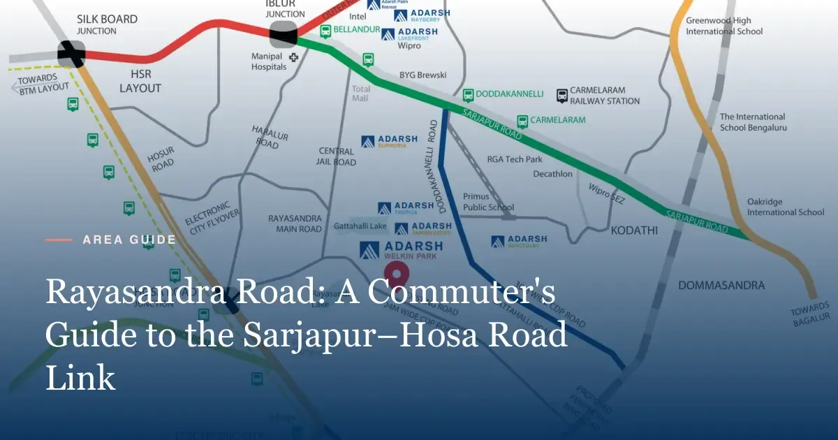
Rayasandra Road is a local link road in southeast Bengaluru. It joins the Sarjapur Road side to Hosa Road, and from there to Hosur Road and Electronic City. A 2021 news report said it can save ORR commuters at least 8 km on the way to Electronic City. Adarsh Welkin Park Apartments sits on this road, beside Gattahalli Lake.
Where Rayasandra Road runs
Rayasandra Road runs through the villages of Rayasandra and Gattahalli, in Sarjapur hobli, Anekal taluk. The area uses the PIN code 560099.
At one end, the road reaches the Hosa Road side. Hosa Road then runs west to Hosur Road, near the Hosa Road metro station. At the other end, local roads lead north and east towards Sarjapur Road.
Here are the main roads a Rayasandra Road resident will use.
| Road | Role for residents |
|---|---|
| Rayasandra Road | Local spine past Gattahalli Lake |
| Gattahalli Road | Local link inside the village belt |
| Hosa Road | Link west to Hosur Road and the Yellow Line |
| Hosur Road | Main road to Electronic City and Silk Board |
| Sarjapur Road | Main road to Iblur, Bellandur and the ORR |
| Outer Ring Road (ORR) | The tech corridor from Silk Board to Marathahalli |
The developer’s location map shows all these links. You can view it on the location section of our homepage.
Junctions that shape your commute
Three junctions, Hosa Road, Silk Board and Iblur, decide most daily trips from this belt. Each one has a known traffic pattern, and each suits a different office location.
Hosa Road junction. This is where Hosa Road meets Hosur Road. It gives the fastest route to Electronic City. The Hosa Road metro station sits on this side.
Silk Board junction. This is where Hosur Road meets the ORR. It has long been one of the most crowded junctions in Bengaluru. Trips to Koramangala, BTM Layout and the city centre often pass here. The Yellow Line now has a Central Silk Board station, which gives commuters a way to skip the road jam.
Iblur junction. This is where Sarjapur Road meets the ORR. It leads to Bellandur and the tech parks along the ORR. Peak-hour traffic here can be heavy in both directions.
A resident on Rayasandra Road can choose between the Hosa Road side and the Sarjapur Road side. That choice is the road’s main strength. On a bad traffic day, one route may move better than the other.
The metro link: Hosa Road station on the Yellow Line
The Namma Metro Yellow Line opened in August 2025. It runs 19.15 km from RV Road to Bommasandra, with 16 stations. It runs along Hosur Road through Silk Board, Kudlu Gate, Hosa Road and Electronic City.
| Station on the Yellow Line | Why it matters from Rayasandra Road |
|---|---|
| Hosa Road | The nearest stop on the Hosa Road side |
| Singasandra | One stop towards Silk Board |
| Kudlu Gate | Two stops towards Silk Board |
| Electronic City | Two stops towards Bommasandra |
| Central Silk Board | Skips the Silk Board road jam |
| RV Road | Interchange with the Green Line |
For a resident near Gattahalli Lake, the metro is not a walk away. You would drive, ride or take an auto to Hosa Road station first. Check the road distance and time on a map app at 9 am on a weekday.
BMRCL has proposed a separate metro line along Sarjapur Road as part of Phase 3A. As of September 2026, no part of it runs. Treat it as a future plan, not a present benefit.
Proposed roads on the developer’s map
The Welkin Park location map marks 4 proposed roads near the site. These are plans, not open roads.
| Proposed road | What the map shows | Status as of September 2026 |
|---|---|---|
| Peripheral Ring Road (PRR) | An alignment near the site | Proposed; no firm opening date |
| 100 ft road | A proposed wide road near the site | Proposed |
| 30 m CDP road | A road in the area’s Comprehensive Development Plan | Proposed |
| 24 m CDP road | A narrower road in the same plan | Proposed |
A CDP road is a road shown in the area’s master plan for future growth. It can take 5 to 10 years or more to build. The state must buy land, find funds and call tenders first. Some CDP roads in Bengaluru have stayed on paper for more than 10 years.
So do not buy a home only for a road on a map. If the road comes, treat it as a bonus. If it does not come, the home should still work for your commute today.
Daily life along the road
Rayasandra Road is not a city high street. It is a local road through a belt of villages, plots and new projects. Expect a mix of old homes, new gated projects and open land.
A December 2021 news report described a 1.5 km stretch towards Hosa Road with potholes and no drains. Residents then said the stretch could take over 20 minutes at peak time. The report named Shanthipura panchayat as the local body. We could not verify the road’s state as of September 2026. Drive it yourself before you decide.
Here is what sits within a short drive, per the developer’s brochure.
| Place | Type | Distance per brochure |
|---|---|---|
| Edenbridge International School | School | 3 km |
| National Public School | School | 4 km |
| TCS | Office | 4 km |
| Springleaf Hospital | Hospital | 5 km |
| Tech Mahindra | Office | 6 km |
| Infosys | Office | 8 km |
| Manipal Hospital Sarjapur Road | Hospital | 8 km |
| Central Mall | Shopping | 9 km |
These are the brochure’s approximate distances, not road trip times. Traffic can turn an 8 km trip into a 40-minute drive at peak hours.
Commute patterns and practical tips
Most residents here work in one of two belts. The first is Electronic City, to the southwest. The second is the ORR and Sarjapur Road tech belt, to the north.
For Electronic City, the usual route is Rayasandra Road to Hosa Road, then Hosur Road. The Yellow Line also helps if your office sits near a station.
For the ORR belt, the usual route is towards Sarjapur Road, then up to Iblur. Office buses often run on Sarjapur Road, so check where your company’s bus stops.
Try these 5 tests before you commit to a home here.
- Drive from the site to your office at 8:30 am on a Tuesday.
- Drive back at 6:30 pm on the same day.
- Try the Hosa Road side and the Sarjapur Road side, and time both.
- Test the auto or cab route to Hosa Road metro station.
- Drive the road once after heavy rain, in September or October.
These tests take one morning and one evening. They tell you more than any brochure distance.
Also think about weekends. On Saturday, trips to Central Mall, 9 km away per the brochure, or to the cafes on Sarjapur Road are easier. Weekend traffic in Bengaluru is often lighter than on weekdays, but malls and main junctions can still fill up by evening.
Two-wheelers change the maths too. Many residents of the Sarjapur belt ride to Hosa Road station and park there. Ask whether the station has parking before you plan on it. A cab or auto from Gattahalli to the station is the other choice.
Finally, check the last mile after dark. Walk or drive Rayasandra Road at 9 pm. Look at the street lights, the footpaths and the traffic. A road that feels fine at noon can feel different at night.
Who a Rayasandra Road address suits
A home on Rayasandra Road suits some buyers far more than others. Here is a plain match guide.
| Your situation | How well it fits |
|---|---|
| You work in Electronic City | Good; Hosa Road and the Yellow Line are close |
| You work on the ORR near Bellandur | Fair; the Sarjapur Road side leads to Iblur |
| You work in Whitefield | Weaker; expect a long drive each way |
| You work in the city centre | Weaker; the metro from Hosa Road helps |
| Your couple works in two belts | Good; the road sits between E-City and Sarjapur Road |
| You want a quiet, lake-side setting | Good, compared with the main Sarjapur Road |
The last two rows matter most for many families. When one partner works in Electronic City and the other near Bellandur, few places split the gap as well. Rayasandra Road sits between both belts, about the same drive from each at off-peak hours.
The quiet setting is the other gain. Main Sarjapur Road carries heavy traffic all day. A home beside Gattahalli Lake sits away from that noise. The cost is a longer last mile on a smaller road.
Schools matter too. The brochure lists Edenbridge International School, Aurinko Academy and Smrti Academy at about 3 km each. A school within 3 or 4 km keeps the morning run short. Compare that with a 10 km school trip across Sarjapur Road.
How Rayasandra Road fits the Welkin Park picture
Rayasandra Road is the front door of Adarsh Welkin Park. The project sits on it, beside Gattahalli Lake. The road’s two-way reach, to Hosa Road and to Sarjapur Road, is its main draw.
The trade-off is road quality and local traffic. A village road takes time to catch up with new towers. Ask the sales team what road works the developer plans at the site entry. The master plan shows a 9 m wide vehicular entry and a bus bay.
If you are still choosing a block, read our Phase 2 guide. If you are weighing a villa, see our villas vs apartments guide. For the full site layout, see the master plan.
Considering Adarsh Welkin Park?
Get the official brochure, floor plans and latest price sheet from our relationship manager.
Frequently asked questions
Rayasandra Road links the Sarjapur Road side with Hosa Road and the Electronic City side of Bengaluru. Commuters use it as a shortcut between the ORR belt and Electronic City.
Hosa Road station on the Namma Metro Yellow Line sits on the Hosur Road side. The line runs 19.15 km from RV Road to Bommasandra and opened in August 2025.
A December 2021 news report described potholes and poor drainage on a 1.5 km stretch towards Hosa Road. We could not verify the condition as of September 2026, so drive it yourself at peak hours.
Adarsh Welkin Park Apartments sits on Rayasandra Road beside Gattahalli Lake, in Gattahalli village, Bengaluru 560099.
The developer's location map marks proposed 30 m and 24 m CDP roads, a proposed 100 ft road and the proposed Peripheral Ring Road. All are proposals, with no fixed dates.
Published by IamHere Realty, authorised channel partner for Adarsh Welkin Park. Project details are from the developer’s official material; verify every detail with the sales team before you decide.